

QUICK JUMP TO: Top things to do / Sports & diving / The Abacos / Acklins & Crooked Island / Andros / The Berry Islands, Bimini & Cat Island / Eleuthera & Harbour Island / The Exumas / Grand Bahama Island / Inagua / Long Island & Mayaguana / Nassau & Paradise Island / Rum Cay & San Salvador
THE EXUMAS

ALLAN CAY IGUANAS
The cay is one of the few places remaining where you can meet and observe the friendly big lizards, who are protected by law.
ROLLE TOWN
The town is one of Exuma's five Lord John Rolle Commonage Estates, which are lands that have been passed down to the slaves and cannot be sold. As a result, the town's current residents are all descendants of John Rolle's former slaves, and have kept many of the traditions perpetuated by their ancestors.

THREE SISTERS ROCKS
According to the local legend, three sisters unknowingly in love with the same Englishman, realised their shared feelings on the day of the gentleman's departure and decided to swim to his ship to confront him, but drowned under the area's rough currents. The rocks where the sisters drowned are said to have grown since that day.

ELIZABETH HARBOUR
With its clear waters made of turquoise and emerald hues and its picture-perfect settings, this is one of the world's largest natural harbours.

EXUMA CAYS LAND & SEA PARK
Created in 1958 and stretching over 178 square miles, this site was the world's first land and sea park, as well as being the Caribbean's first no-take reserve, and is famous for its impressive marine life, making it a perfect diving and snorkelling spot.

MORIAH HARBOUR CAY NATIONAL PARK
A 13,440 acres national park established in 2002 preserving the ecosystem between Great and Little Exuma, with a marine environment including sand dunes, pristine beaches, mangrove creeks and sea grass beds, which are home to a wide variety of seabirds such as the Gull-billed and least terns, nighthawks, plovers, oystercatchers and ospreys.
“ ”
GRAND BAHAMA ISLAND

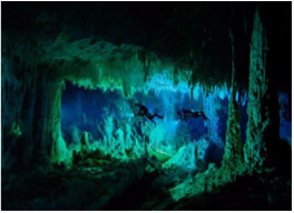
BEN'S CAVE
This spot, named after UNEXSO legend Ben Rose, is one of the two inland blue holes within the Lucayan National Park, and is an exciting diving site with a cavern system that horizontally extends for thousands of yards and is said to be one of the world's longest surveyed cave systems, featuring formations such as stalactites, stalagmites, a halocline, fossilized conch shells, and bivalves.
LUCAYAN NATIONAL PARK
This 40-acre National Park features one of the world's largest underwater cave systems, with two caves open to public, as well as nature trails and boardwalk leading to healthy ecosystems. Please note that swimming in the caves is prohibited and that divers require a special permit.

PINDER'S POINT LIGHTHOUSE
Built from the late 1700s to the early 1800s, this lighthouse used to warn sailors about their proximity to the rocky shoreline and unreliable shoals. Its 2009 renovation saw the old kerosene system replaced by the modern automatism most of the country's lighthouses now feature.

FERN GULLY / JOSEY CAVE & NATURE TRAIL
A nature trail taking you through the thick landscape make of native vegetation, endemic and migratory bird species, insects, butterflies, lizards, and leading to the Fern Gully, a large fertile sink-hole with rare species of ferns, referred to as leather-back.

MERMAIL POND
This fresh water spring is believed to be linked to the ocean, located a thousand feet away, by an underground network of cavern, and is a testament to the cavernous geology of The Islands of The Bahamas. Visitors can witness water in the hole moving one hour before high tide and the blowing comes one hour before low tide.

RAND NATURE CENTRE
100 acres of natural beauty in the heart of Freeport with a 2,000-foot trail taking hikers through natural coppice and pine forest, with great bird-watching opportunities, especially from October to May.

HAWKSBILL CREEK NATURE TRAIL
Named after its once frequent but now heavily endangered visitor, the Hawksbill Turtle, the area showcases the contrast between the natural and industrial landscape of Grand Bahama Island, highlighting the resilience and importance of its mangrove system, being one of nature's toughest living species, and one that creates a healthy environment for more fragile living organisms.

PETERSON CAY NATIONAL PARK
This protected cay, situated a mile offshore, is a great location for bird-watching, as well as snorkelling and diving, due to the active coral reefs surrounding the land.

THE BOILING HOLE
The site takes its name from the effect created by tidal flows from the sea, causing the water rushing from the area beneath the roadway to bubble on the surface. Equally, when the tide flows inward, the water rushing into the cavern system creates an impressive whirlpool.
“ ”
INAGUA

INAGUA LIGHTHOUSE
One of the country's three remaining kerosene-burning lighthouses, this 1800s 113 feet-high tower offers panoramic views reaching as far as 17 miles, including vistas of neighbouring Matthew Town.

SALT POND HILL
Located on Inagua's south coast and rising to 102 feet, the site features the stone remains of what is believed to have been a small hut built by a shipwrecked crew from the French vessel "Le Count De Paix" in 1713.

INAGUA NATIONAL PARK
Established in 1965 and spreading over 183,740 acres, this park is known for being home to the world’s largest breeding colony of West Indian flamingos which, 40 years after being nearly extinct, counts approximately 50,000 birds.
THE SALT HOUSE
Once used as a warehouse during the salt industry's early days, this 18-19th century edifice features a doorway that is believed to have been built using stones from the ruined town of Port Royal in Jamaica, West Indies.

LITTLE INAGUA NATIONAL PARK
With a protected land of 31,600 acres, the largest uninhabited island in the wider Caribbean was designated a National Park in 2002, to serve as an undisturbed nesting location for the area's endangered turtle species.

UNION CREEK RESERVE
This 4,940 acres reserve was established in 1965 and stretches over an enclosed tidal creek on the northwest shore of Great Inagua, serving as a prime habitat for young Green Turtles and Chelonia mydas, and is not open to the public in order to preserve the undisturbed nature of the endangered species living on site.
“ ”
LONG ISLAND & MAYAGUANA

ADDERLEYS PLANTATION RUINS
Stretched over 700 acres of land that once comprised all of Stella Maris, this cotton plantation was granted in 1790 to Mr Abraham Adderley, a British born business man established in Nassau. Thirty years later, the land was extended by Adderley's son, William, to 2,500 acres, housing livestock, crops and cotton.

LONG ISLAND MUSEUM
Get deeper into the roots of Long Island by visiting this museum retracing the life of the island from the 1800's to the 2000's, through exhibits as well as utensils and objects once used by settlers, and items reflecting the past traditions of the island's inhabitants.

STELLA MARIS CAVE
Stalagmites, stalactites and colonies of bats can be found in this cave which is one of the smallest on the island, and which is often used by resorts to host group parties during the winter months.

DEAN'S BLUE HOLE
Believed to be the world's deepest blue hole and second largest underwater chamber, Dean's Blue Hole is 25 x 35 metres at the surface and dips about 203 metres into the ocean floor right offshore, with its diameter opening out after 20 metres into a cavern of at least 100 metres (diameter).

ABRAHAM'S BAY TOWN SQUARE
The square features symbols of the island's cultural heritage and marks of its past, such as the old Charlton House, the Zion Baptist Church and Church of God of Prophecy, as well as an old well shack.

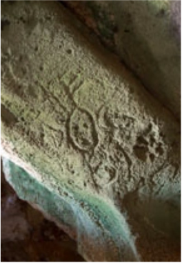
HAMILTON'S CAVE
With passages at least 50 feet wide, and a ceiling over 10 feet high, this is one of the largest caves in The Bahamas, and one where Lucayan artefacts were discovered, back in 1935.

WODDIES PLANTATION
Originally owned by Bruce Fritz Morris, one of the early settlers from England who sold the property after having to return to England with the yellow fever, the 9,000 acres land was purchased by John Woodes in the early 1700s.

PIRATE'S WELL
This point of interest and settlement was named after the buccaneers who used to wander in the area and dig up a well from which they could drink fresh water.
“ ”
NASSAU & PARADISE ISLAND

ADELAIDE VILLAGE
Located on the southwestern coast of New Providence, this historic site was one of the villages created in 1831 by then Governor of The Bahamas, Sir James Carmichael Smyth, to house African communities disembarking from slave ships. Adelaide's first settlers were 157 of the enslaved Africans captured by the British Royal Navy from the Portuguese vessel 'Rosa' in 1831.

BONEFISH POND
This 1,280 acre park was established in 2002 and is a major marine nursery, being home to juvenile fish, crawfish, and conch, as well as being a haven for waterfowl and a variety of Bahamian Flora.

FORT CHARLOTTE
Spread over a hundred acres, this 1788 fort is located on a hill that overlooks the harbour's west end and offers beautiful views of the surrounding areas including Paradise Island and Nassau. It features a moat, dungeons, underground passageways and 42 cannons.

FOX HILL
This one of the country's oldest villages, named after Samuel Fox, an enslaved African who, upon being freed, was granted 23.5 acres of land at Creek Village in 1801.

HOG ISLAND LIGHTHOUSE
Located at the western end of Paradise Island, this 1817 lighthouse marks the northwest entrance to New Providence and the Port of Nassau, and is believed to be the country's oldest and most famous lighthouse, as well as the West Indies' oldest surviving lighthouse. It is named after the island's previous name, Hog Island.

NETTIE'S PLACE
This attraction is a firsthand view of The Bahamas of yesteryear, taking visitors through the ancient lifestyle and traditions of the country, with a collection of historical artefacts and exhibits retracingwhat life was like in the village over the past century.

POMPEY MUSEUM
Housed in the 1769 Vendue House, more commonly known as the Bourse, a marketplace selling Enslaved Africans and other "commodities" during the 18th and 19th centuries, this museum opened in 1992 and was named after a courageous slave who lived on the Rolle Plantation on Exuma's Steventon.

THE CLOISTERS
Located on Ocean Drive and overlooking the Nassau Harbour, the remains of this 14th century French monastery are a popular site for weddings, and belong to one of the four sites to have ever been removed from French soil.

THE DEANERY HOUSE
Built around 1710, this beautiful three-storey-house is believed to be one of the country's oldest residences.

BAHAMA'S HISTORICAL SOCIETY MUSEUM
The Bahamas Historical Society is a non-profit cultural and educational organization that aims to create interest in Bahamian History, as well as collecting and preserving artefacts, items, and documents relating to that history. It was founded in 1959 by Lady Arthur, the wife of the then-Governor of The Bahamas, Sir Raynor Arthur.

CHRIST CHURCH CATHEDRAL
Originally built in 1670 by the Lord Proprietors, this was the first church in The Bahamas, although the present structure, which was built in 1841, is the fifth edifice that has occupied the spot. In 1861, Nassau became a city and Christ Church became a cathedral.

FORT FINCASTLE
This fort was built in cut limestone in the 1790s and placed at the top of Bennet's Hill to protect the historic town of Nassau.

GAMBIER HISTORICAL VILLAGE
Established in the early 1800s by a community of liberated African men and women after the abolition of the slave trade in 1807, this village is one of the oldest settlements in Nassau.

GOVERNMENT HOUSE
Located on Mount Fitzwilliam, the official residence of the Governor General of The Bahamas was built in 1801 and is set over 10 acres of land. The pink and white edifice is a great example of Bahamian-British and American Colonial architecture.

JACARANDA HOUSE
Originally known as Anderson House, then Everton House, and being also knwon by some as the Old Miller Place, this 1840's stately home was built by then Chief Justice, Sir George Anderson.

PARLIAMENT SQUARE
Built in 1815 by the Loyalists, the buildings composing Parliament Square are a great example of old Nassau's colonial architecture, one that partly took inspiration in the edifices found in South Carolina's old capital, New Bern. On the square you will find the House of Assembly, the 1905 statue of Queen Victoria, and the Supreme Court, amongst others.

QUEEN'S STAIRCASE
This important landmark, often referred to as the 66 steps, is located in Nassau's Fort Fincastle Historic Complex, and was carved out of solid limestone rock by slaves in the 1790s . It is believed that it was built to provide a direct route between the fort and Nassau City.

STRAW MARKET
Venture into the heart of Nassau, near Bay Street Shopping Centre and George Street, and you'll find the Straw Market tent which is perfect for grabbing yourself a little bargain to take home; shop for handcrafted Bahamian treasures including signature straw hats, beautiful handmade woodcarvings, tubs of Guava Jelly and other island souvenirs.

THE NATIONAL ART GALLERY OF THE BAHAMAS
Found at the historic Villa Doyle, the NAGB displays a collection of historical and contemporary art reflecting the country's cultural heritage, practices, and movements through a variety of exhibitions as well as its in-house art library.

BAY STREET
Nassau's main street is a busy shopping area visited by millions of tourists every year, and is lined with architectural examples reflecting the country's past as a British Colony.

CLIFTON HERITAGE PARK
Clifton Heritage Park was established in June 2004 to preserve the Lucayan, Loyalist, and African cultural and historical legacies that compose the country's heritage. Its nature trail reveal a lush composition of native coppice, cliffs, coastal wetlands, dunes, rocky shorelines, sandy beaches, and offshore coral reefs, where you may encounter local bird species such as songbirds, wading birds, seabirds, and other wildlife.

FORT MONTAGU
Built of local limestone in 1741, this is the oldest fort that is currently still standing in New Providence, and is located at the eastern end of Nassau.

GREGORY'S ARCH
Built in the mid-19th century, the stone arch was named after Governor John Gregory -who served around that time- and marks the frontier between Nassau and the rest of the island.

NASSAU PUBLIC LIBRARY READING ROOM & MUSEUM
Originally built as a jail in 1797, this was the first edifice to be constructed in Parliament Square. In 1879, the octagonal-shaped building was converted into a library, reading room, and museum.

PIRATES OF NASSAU
This wax museum retraces the country's pirate era, featuring reproductions of battles including sound and light effects, and displays depicting the buccaneers' lifestyle.

ROYAL VICTORIA GARDEN
Located on Shirley Street, just opposite the Nassau Public Library, the gardens were originally part of the former Royal Victoria Hotel which, built in 1861 by the Bahamas Government, was the country's first luxury hotel.

ST MATTHEW'S ANGILICAN CHURCH
First opened for services in 1802, St Matthew's Church is The Bahamas' oldest still standing church building. Its clock, which was erected in 1816, was for a long time one of only two reliable time pieces on the island.

STATUE OF CHRISTOPHER COLUMBUS
You can find this homage to the famous explorer in Duke Street, at the front of the Government House.

XAVIER'S COLLEGE
Established in 1889 by the Sisters of Charity, this Roman Catholic School was the country's only girls' school, and was the equivalent to the boys' school St Augustine's College. In 1967, both schools merged with St Augustine's becoming a co-ed high school, and Xavier's becoming an elementary school for boys and girls aged 5 to 12 years old.
“ ”
RUM CAY & SAN SALVADOR
HARTFORD CAVE
Rum Cay residents would often come to the cave to collect bat droppings which they would use as natural fertiliser, until they started finding clay utensils such as plates and bowls underneath the thick layer of excrements that covered the cave, and later found the items were in fact of Lucayan and Arawak origins.

DIXON HILL LIGHTHOUSE
This 163 feet tall lighthouse is one of the island's most popular landmarks, and one of the few remaining manually-operated lighthouses in the world, and one of the three in The Bahamas. It was built in 1887 on the lands of a former plantation owned by John Dixon.

COLUMBUS MONUMENT
Located at Long Bay, which was named after the boats used by Columbus and his crew, the monument marks what is believed to be the exact spot where the explorer dropped anchor on the 12th October 1492.

FORTUNE HILL PLANTATION
Located in the middle of San Salvador's eastern coast, this plantation was owned by Burton Williams in the late 1780s and was the island's largest plantation at the time. Visitors can still see the ruins of the limestone Great House, which is a display of the dominant British colonial Georgian architecture of the 18th and 19th century.

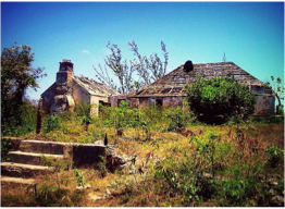
WATLING'S CASTLE / SANDY POINT ESTATE
Named after George Watling, a buccaneer who used to frequent the estate, the ruins of this late 18th century Loyalist plantation are located in Sandy Point, and include a three-storey Great House, slave quarters, a kitchen, barns and boundary walls, and features a recently renovated lookout tower that offers beautiful views of French Bay.

CUT CAY
In his journal, Columbus refers to this small island located beyond a shallow channel off North Point, and which is accessible by foot at low tide. The explorer described it as a good spot for a fortress.

CHICAGO HERALD MONUMENT
Made out of native limestone, this monument was erected by American newspaper the Chicago Herald at the occasion of the 400th anniversary of the discovery of the New World, during the 1892 World's Fair that was held in Chicago.
“ ”